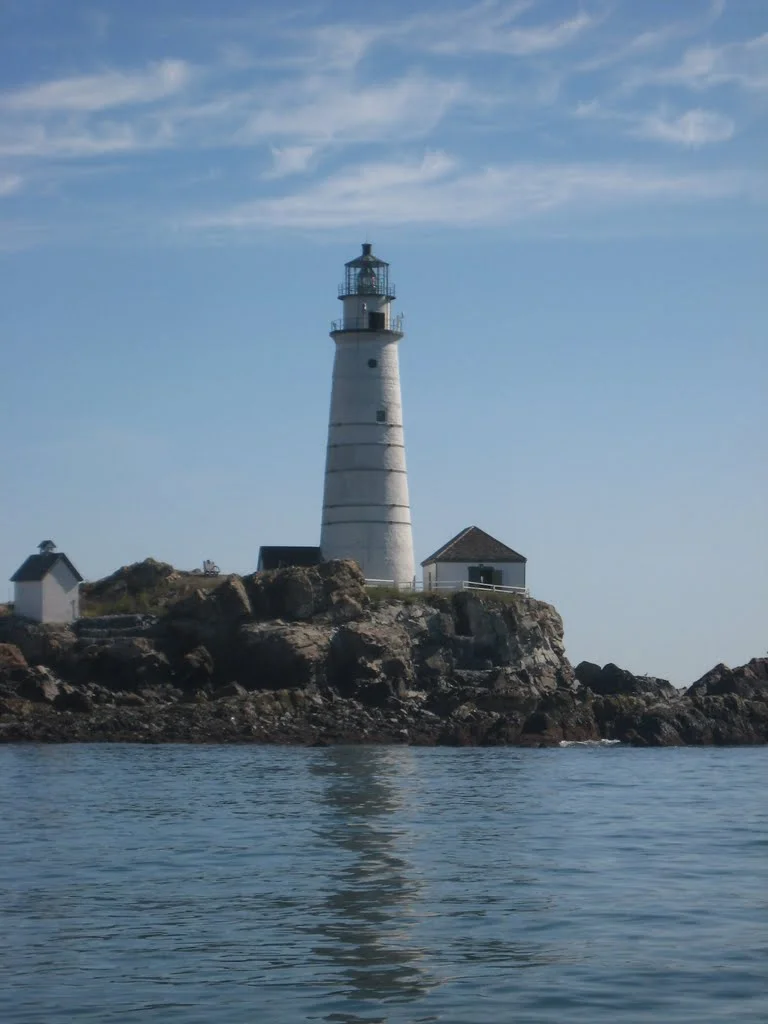

The historic Boston Light Swim starts at America’s first lighthouse, the Boston Lighthouse on Little Brewester Island, and meanders for 8 miles among several of the inner harbor islands before finishing on the beach next to the L Street Bathhouse. Due to sea conditions, wind, currents, and waves, the actual distance traveled is typically a bit farther than 8 miles, BUT the tidal assistance swimmers receive makes this swim feel more like a 10K than an 8-mile swim.
Course Navigation Tips
The current will be strong (~1 mph) in the first half of the race and thankfully, it's running in the right direction! (Yes, we do that on purpose. That's why the date of the swim varies from year to year and the start time can fluctuate from stupid o'clock to rational-human-being time. It all depends on when the incoming tide is scheduled to begin.) Swimmers can expect to get some current assistance, especially in the first two or three miles, but wind and other conditions may negate this effect. The race start is timed to coincide with favorable tides to permit as many swimmers as possible to finish the course.
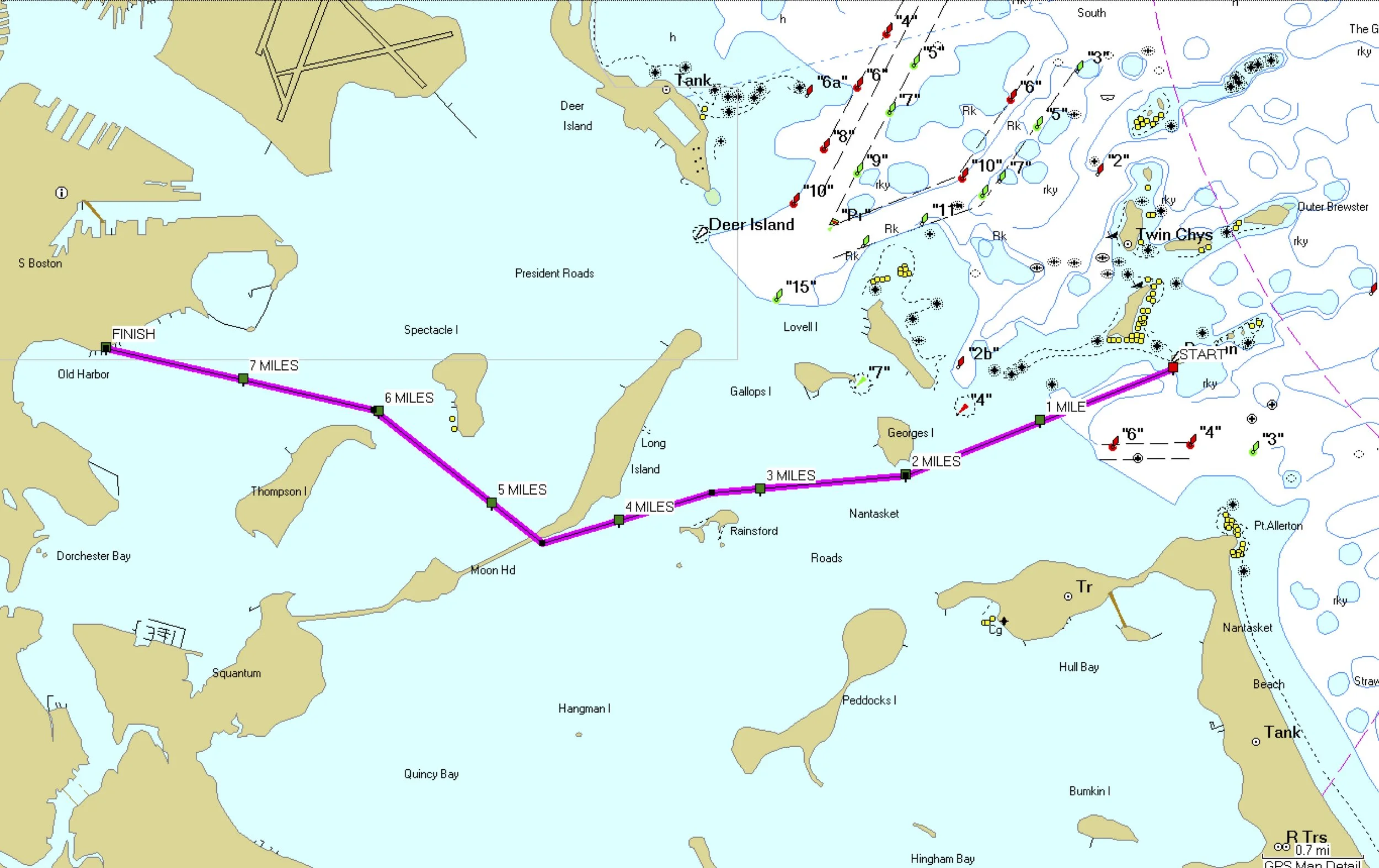
The race begins in the water at the foot of the Boston Lighthouse on Little Brewster Island. At the sound of the horn, swimmers will begin swimming towards Georges Island, passing along the southern side of the island (2 miles). The course continues straight, passing north of Rainsford Island (3.3 miles). Swimmers should continue heading for the southern tip of Long Island (4.6 miles). You'll then round the southwestern edge of Long Island. The bridge is no longer there to help guide you, but some of the stanchions remain to mark where it once stood as a rusting hulk. Because of the current, the time to this point (a bit past the halfway mark to the finish) can be as fast as 1.5 hours, but water and weather conditions may alter this time.
Beyond the tip of Long Island, currents will be running nearly perpendicular across the course until swimmers near Thompson Island (6 miles). As you near Thompson, the island’s land mass offers some protection from the current, but it takes a while to get there and some swimmers have reported being pushed towards Moon Island as they traverse the open area after the bridge. Therefore, it’s best to stay close to Long Island when swimming under the bridge and take an angled approach to the eastern tip of Thompson Island—this approach offers a little more leeway if the current is strong.
From Long Island into L Street, the water can be choppy as a result of boat traffic. But starting early in the day means there should be lighter traffic by the time most swimmers reach this area. Once swimmers have passed Long Island, the choppy conditions, boat traffic, and currents demand that swimmers and escort pilots pay extra attention to their surroundings and be ready to react to sudden shifts in conditions or traffic.
The course continues its north-westerly path, clipping the north-eastern tip of Thompson Island. (In recent years, swimmers have reported getting caught in a swirly back-current off Thompson Island, which is another reason to stay a little bit to the east on that section of the course rather than trying to cut the island very tightly. It’s also very shallow close to Thompson, so if you do find yourself closer than you want to be, keep your eyes peeled for rocks.)
The course then angles a bit more west and cuts straight across Dorchester Bay to the finish at the L Street bathhouse. There are several buildings on the Boston skyline that can be helpful in navigating to the finish line. Particularly, a tall rectangular appartment building to the left of the bathhouse can be seen soon after swimmers near Thompson Island.
Once swimmers have passed the yacht club, they may also be able to see the L Street Bathhouse building, a short, wide, and reflective white building that is a welcome sight to swimmers nearing the end of the race. Aligning to the left of the Hancock and Prudential buildings is also a common sighting strategy.
During the race, heading for the proper side of the next island is the best navigation method. Finding the finish line can be difficult, particularly if there is a lot of boat traffic, the visibility is poor, or the swimmer is unfamiliar with the course.
There will be a large FINISH banner on the beach that usually becomes visible within the last half mile of the race. Swimmers must exit the water and finish on land at the marked finish line for an official time and place to be recorded.
The best advice for swimmers unfamiliar with the Boston Harbor and the course is to spend some time with a good map of the harbor and the course map on this site. It’s also a good idea to look backwards as you motor out to the start so that you can select landmarks to sight from during the race. If your escort vessel is equipped with a GPS system, that will make staying on course even easier.